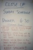
March/April 1993
Gathering at DFW Airport to depart for DC. Then... the hotel lobby.


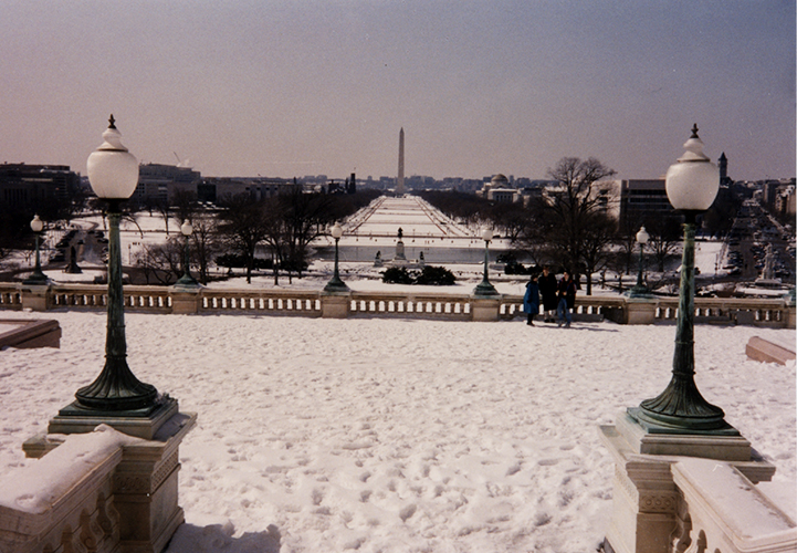
The DC Metro - the only way to travel.


In the Rayburn House Office Building to visit with our Congressman - John Bryant, TX, 5th (D). Later Crysatl meets Senator Edward (Ted) Kennedy, Democrat from Massachusetts and brother to JFK.


End-of-the-week banquet/talent show/dance. During the evening "the storm" began to move in...


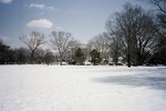
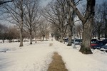
It was an historic storm. Streets were impassable, winds were strong, snowdrifts, the airports closed - even the Metro was closed. Our departure - and all the Close Up participants - was delayed for three days. What an adventure!


Bonus!
Three extra days in DC because of the "Superstorm of 1993."
Posted at 12:00 PM ET, 03/16/2008
The Superstorm of March 13, 1993
By Kevin Ambrose
I will always remember the weather forecast issued on March 12, 1993 for the storm expected to hit the East Coast the following day. It was the first time I ever heard a blizzard warning issued for Washington, D.C. The forecast for March 13 was quite ominous and included forecast snowfall totals in the range of 12 to 24 inches with warnings about blowing and drifting snow. Ultimately, the snow changed to sleet and rain in DC and points east, but west of Washington experienced a truly historic snowstorm. Below is a summary of the event.
The "Super Storm" of March 13, 1993 will go down in history as one of the largest winter storms on record. Heavy snow and blizzard conditions extended from the Gulf States to New England and from the Ohio Valley to the East Coast. Hurricane force winds battered cities along the Atlantic Coast. Deadly tornadoes were spawned in Florida and tremendous waves and tides occurred from Key West to Maine. The storm was so large that its effects were felt from Cuba, where high winds and rain damaged the sugar crop, to Chicago, where 250 flights at O'Hare International Airport were grounded due to snow squalls. Approximately 270 deaths were attributed to the storm, three times that of Hurricanes Andrew and Hugo combined.
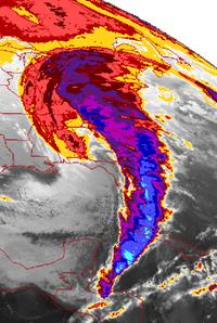
Satellite image by NASA of the 1993 North American Storm Complex on March 13, 1993 at 10:01 UTC.
The storm originated as a cluster of thunderstorms over Texas on the morning of March 12. As the late winter storm moved over the warm Gulf of Mexico waters, a storm of hurricane proportions began to take shape. Many buoys in the central Gulf recorded wind gusts over 100 mph. A cluster of tornadoes hit Florida, while at the same time an 11-foot tidal surge hit the west coast of Florida during the night of March 12-13. A total of 44 people died in the Sunshine State.
The highest recorded wind gust associated with the storm occurred on Mount Washington, New Hampshire where the wind was clocked at 144 mph. Dry Tortugas in Florida (west of Key West) recorded a 109-mph wind gust; Myrtle Beach, South Carolina recorded a 90-mph wind gust; and Fire Island, New York recorded an 89-mph wind gust.
Incredible snow totals occurred with the storm, including 50 inches at Mount Mitchell, North Carolina; 43 inches at Syracuse, New York; 30 inches at Beckley, West Virginia; 25 inches at Pittsburgh, Pennsylvania; 20 inches at Chattanooga, Tennessee; 15 inches at Birmingham, Alabama; and 14 inches at Washington Dulles Airport.
Record low pressures accompanied the storm. All-time record low pressures include 28.38 at White Plains, New York; 28.54 inches at Washington; 28.64 inches at Columbia South Carolina; and 28.86 inches at Tallahassee, Florida.
During the evening of March 12, heavy snow broke out from Alabama through the western Carolinas. The snow spread rapidly northeast, reaching D.C. shortly after midnight. It became moderate-to-heavy during the morning. By then, most of the area had received 4 to 8 inches of snow.
During the late morning, sleet began to mix with the snow, especially from Washington south and east. By early afternoon, many areas experienced rain. By evening, the precipitation had changed back to snow. The snow was accompanied by high winds, with a peak wind gust at National Airport recorded at 47 mph.
The period of mixed precipitation in the Washington area kept accumulations down, with 7 to 12 inches common in D.C. and the close-in suburbs. At National Airport, 6.6 inches of snow fell; at Dulles, 14.1 inches of snow fell; and at BWI, 11.9 inches of snow fell. The heaviest accumulations were generally west of the city, but there were also pockets of 12-plus inches of snow to the southeast and northeast of the District. Generally, the liquid totals for the storm were in the two to three inch range.
By Kevin Ambrose | March 16, 2008; 12:00 PM ET